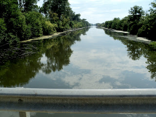
We drove down to the park office restrooms and parked, it was sprinkling on and off and we decided to head out any way. We rode 10.3 miles to bridge # 7 where we turned around and headed back to the park office where we parked the car.
Be sure to double click on the pictures to enlarge them to see the details
Bridge #7 our turn around point
Lock 14 looking east to bridge 7
Lock 14 looking west
Lock 15 looking east
Lock 15 Spillway where the gates used to be
Lock 15 looking west to lock 16
Lock 16 Miter Gates
Lock 16

Lock 16 upper gate, unique design, this gate has a horizontal pivot axis.
The top of the gate pivots down rather than swinging open.
It was designed by the Chief Engineer for the canal, William Marshall.
East end of Lock 17 with Bridge 9 in the distance
Roller system to move Bridge 9A from across the Lock 17
Aqueduct 3 which carries the canal over the West Bureau Creek
Looking south from Aqueduct 3 at the West Bureau Creek
East end of Lock 18

West or Upper end of Lock 18
Bridge 10A open truss design moved here from down by Tiskilwa to preserve it
Lock 19 with Bridge 10 in the background
Lock 19
Lock 19 with Roman Numerals to show water depth
Rail Road Bridge #3
Lily pad pond under Rail Road Bridge #3 and to the east of here
Lock 20 as seen from the east
Lock 20 looking east

Lock 21 from the east, lift bridge is visible

Lock 21 looking east, lift bridge at the east end
Lock 21 looking west
Barge Dry Dock just west of Lock 21
Coming up on Bridge 11 from the east, this is the spot on the canal where we used to swim when I was a kid..
Just west of Bridge 11 the Fish Hatchery Pond
East side of Bridge 12
Coming up to the east side of Bridge 13 which is very overgrown
West of Bridge 13
Looking east on Bridge 14
Looking west on Bridge 14
Rail Road Bridge 4 with Route 40 Bridge 14A in the background
Bridge 14A Illinois Route 40
Last bridge on this days ride Bridge 15
The Rest Rooms at the Picnic area near the Visitors Center where we started


Your images of the canal are outstanding. They are professional in quality and I wish I had a book containing every one of your photos. Many years ago I fished the Hennepin canal, and I may someday return to it.
ReplyDelete