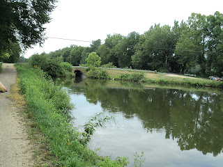
Looking east from Lock 2, Lock 1 is a mile east of here and 1.3 miles east is the Illinois River, This is where the trail ends.
Lock 2 from the east
Culvert showing at up stream side of Lock #2,
the culvert allowed water to flow into the lock,
so that water flowed down stream when the gate was closed.
In most locks this culvert is not visible because the water level is
high enough to cover it. The water in this lock is low all the time as the canal is ending its journey and the river ahead isn't that much lower.
It would be nice to see Lock # 1 and see its layout.
Lock 2 looking west
Before Rail Road Bridge # 1 Bank repairs, difficult and dangerous to maneuver,
walk your bike here. Rail Road Bridge # 1 in background
Rail Road Bridge 1
Bridge 1, Rte 26& 29 south of Bureau Junction, IL
Lock 3 from the North bank
Lock 3
Lock 3 looking east to Bridge 1
Lock 4 looking east
Lock 4 west end blocked off, because Aqueduct # 1 has collapsed and is gone
This is the bridge over where Aqueduct # 1 used to be.
Looking north from the Aqueduct #1Bridge
Looking south from the Aqueduct #1 Bridge
Coming up on I-180 Bridge #1B
Lock 5 from the east
Lock 5 looking east
Lock 5 spillway
Lock 5 upstream depth markings, double click to see better
Coming up on bridge 3 from the east
Bridge 3 looking east
Bridge 3 looking west
Rail Road Bridge #2 from the east
Rail Road Bridge #2 looking east
Lock 6 looking east at RR Bridge #2
Looking west in lock 6
Lock 6 Spillway
Looking west from Lock 6
Looking east from Lock 7
Lock 7 spillway
Coming up on Bridge 4 from the east
Bridge 4 looking east
Bridge 4 looking west
Coming up on Lock 8 from the east
Lock 8 looking east
Lock 8 looking west at Lock 9
Lock 9

Lock 9 looking east
Looking west from Lock 9
Bridge # 5 from the east
Bridge # 5 looking east
Bridge # 5 looking west
Lock 10 from the east

Lock 10 looking east
Lock 10 looking west
Coming up on Bridge 6 from the east
Coming up on Lock 11

Looking east out of Lock 11 bridge 6 is visible in the distance
Looking west from Lock 11 at Bridge 6 A
Bridge 6 A looking west
Lock 12 looking east

Lock 12 remains in Gate area

Just west of Lock 12 is the remains of Aqueduct #2, the large slabs to the left of the picture are the sides of the Aqueduct.
This is the bridge that goes over the location where Aqueduct # 2 used to be

Coming up on Lock 13 from the east

Lock 13 looking west
Back to Bridge # 7 where todays ride started.


