Monday, September 30, 2013

Sunday Sept 29th bad day for a ride.

Yesterday on our bike ride, I crashed into one of two "BMX'rs" a type of dirt biker. Below is a picture of the type of bike.


The RED arrow shows the direction I was going and the WHITE arrow shows where the crash took place
  As we were coming up to the tunnel under the rail road track on the north side of the Dam walk way,the two of them came down the hill through the tunnel and were on the wrong side of the path.


The X shows where the collision took place, on my side of the path

 The first one clipped my mirror and the second one came directly in front of me and I hit him broadside, he went flying and I landed on the path, my bike worse for the wear, his bike "broken" in his words, he said "Dude are you alright", I replied I would be if you stayed on your side of the path.  He said "I couldn't control it!", meaning -  first of all these bikes like his have no brakes and he was going too fast, 20 mph +. He picked his bike up and walked away. 

His buddy after he clipped my mirror, was looking back to see what would happen to his buddy, almost ran into Judy but she managed to swerve out of his way. I had to put my chain back on to ride back home, ride discontinued.
Blood on the path from the laceration on my right knee, which dripped there while I put my chain back on.


 By the time I got back across the bridge, my right hand hurt so bad I couldn't hold on to the handle bar.

This morning I had a scheduled Dr apt at the VA and because of my hand swollen and hurting they x-rayed it and confirmed the first bone in the hand that is part of the little finger is broken right where it would have been on the hand grip. The Dr referred me to a surgeon in Iowa City, have to wait to hear from him. Looks like my outdoor riding is over for this year, he said no bike riding for a month, which combined with the surgery already scheduled for 10-24-13 really ends this years outdoor riding. SO I guess I will set my bike up on a trainer and start riding inside early this year.
RED arrow shows where the bone is broken. Swelling is worse than the picture shows.

Here is my cast and the repairs to my bike came to about $70.00, I get to keep the cast for 6 weeks, but we did ride day before yesterday.


Sunday, September 22, 2013

Ride of the Hennipen Feeder canal from Rt 92 south and back

Today we decided to ride south from Rt 92 to see how the mowing had proceeded, it was mowed but just barely and the weeds in the middle of the path were untouched and still at least 2 foot tall. We hadn't gone far when we came on a tree hanging across the path, I stopped and broke the limbs back until the path was clear, when I rode on Judy was far ahead of me so i rode hard to catch up, soon I saw her in the distance walking towards me pushing her bike, she had a flat. So I got out my patch kit and fixed it, soon we were on our way again. We rode about a mile and she had another flat, DAMN! So I tore the tire apart and found the leak, about 2" from the last one, so after patching the tube again, I checked and re-checked the tire.

The offending tire


Finally I found a little sliver of glass, only by flexing the out side of the tire did I find it. While fixing this flat along came a guy on a bike headed north, we talked and found out he was from Princeton and used to live in Walnut, his ex still lives in walnut and about 6 months ago she had contacted me about old walnut pictures and wondered if I had one of the house she lives in, I did. Small world. He headed north and we continued south and we turned back north at about bridge 62.

On our way back to Rt 92 we came to Aqueduct 9, there were 2 young Amish boys resting there with their bikes.

Soon we met our traveler from Princeton biker on his return trip about where we had talked to him before.

 We finally arrived back at Rt 92 and had enjoyed a great ride, other than the flats.

Here is the link to the Garmin Report.
http://connect.garmin.com/activity/379908243

Monday, September 2, 2013

The Great River Trail ride on 9-2-2013

As today was Labor Day we decided to ride another section of the Great River Trail, we drove to Rapids City and Parked at Shuler's Shady Grove Parking lot.


We rode south under I-80 and continued on to Hampton, IL 


and soon we came to Lock and Dam 14.


This is the old Arsenal Power Plant which connects Sylvan Island to Arsenal Island.


I- 74 Bridge in the distance.


Lock and Dam 15 and the Government Bridge.


This was our turn around for the day, a plaza across from Lock and Dam 15, with Centennial bridge in the back ground.

On our way back I shot this picture of an old abandoned depot, with the Kone Tower in the background.
Our round trip today was right at 30 miles, it was a beautiful day for a ride, after all of the HOT weather we have been having.


Ride to Sauk Valley College on August 31,2013

http://connect.garmin.com/activity/369619227

Here is the Garmin Report of our Ride from Rock Falls, across the Upper Dan walkway, ride through Sinnissippi Park down Mound Hill Road to Route 2 and stop at Sauk valley College. Be sure to switch to the Satellite view.


Riding the Great River Trail - From Cordova to rapid City,IL 8-25-13

We decided it was time to get back to the Great River trail, so we drove over to Cordova, IL and parked the car and headed south.

They have some unique sign posts along this section


All of them are bike parts adorning the posts


The path runs along the highway for most of the distance to Rapids City


Coming into Port Byron, IL


There is a great parking lot along the highway, it is Shady.


Not long after you pass Shady Grove you will come to I-80 as it crosses the Mississippi.


Just past I-80 we turned around for our return trip.


More sign posts


The Mississippi at Port Byron.


On the Hennipen Feeder Canal August 10, 2013

We drove down to IL Rte 92 and parked and rode south on the path, what we were greeted with was sad, this section of the path is paved, but hasn't been mowed in over a year, what is interesting is that the Horse riding path on the east side of the canal looks to have been mowed regularly.
The first thing we encountered was a tree across the path, this has been across the path so long the bark is wore off where people have drug their bikes over the trunk.


 Next we came to the worst section as far as being unmowed, the grass was growing up thru the pavement in several spots over a mile long section

As tall as this grass is it has to have been over a year since this section was mowed.


North of the aqueduct we came upon this brush, which had been trimmed off the over hanging trees and left where it fell on the path, 
it has been here so long it was completely brown.

I realize that the state is short on money, but this is the poorest maintained path we ride on in the state of Illinois, which is too bad because it is one of the most scenic.

Sunday, June 9, 2013

The Great River Trail - From Albany, IL to Cordova, IL

Today we drove to Albany and parked at the Albany Mounds Park to get on the trail, Previously we have ridden from Savanna, Il to Thompson and from Thompson to Fulton and then to Albany, so today we tackled the next 10 mile one way section, for a round trip of 20 miles. Once we got to Cordova, IL we looked for a place to have lunch and we found the Drifter's Cafe right on Illinois Highway 84. Nice clean restaurant with good food, huge clean restrooms and a friendly efficient waitress. On the trip south we had a 10 mph. headwind and some tough hills. The path is paved with asphalt and 99% of it is on a separate bike path, with minimal street riding, well kept almost all the way. It took us 68 minutes to go 10 miles against the stiff wind, but coming back we managed it in 47 minutes and that included 3 stops for some sight seeing. So having the wind to our backs really made a difference.
 Rest Rooms at Albany Mounds Park at the Trail Head parking lot.

Start of the paved trail through Albany Mounds Park.

 Albany Mounds Park.


Heading into the Timber in Albany Mounds Park.


First real hill in the  Park, the hill are from 3 to 10% incline, so they are a workout.


 Judy ahead of me on the path coming to the south side of Albany Mounds Park.


 The path along IL State Route 84


                     After Lunch in Cordova, we headed back north and here we are about 2 miles 
                                                              north of Cordova.

See the facts of the ride and a overhead view of our ride at    http://connect.garmin.com/activity/325542694  be sure to switch to the satilite view!

Wednesday, May 22, 2013

Cruise Illinois


http://www.youtube.com/watch?v=o9x3Ca1u978&list=PLF969E9D9FA94FCB0

Check out this video and others related Cruise Illinois, A segment from WGN-TV's 2009 Crusin' Illinois series. Join WGN-TV's Julian Crews as he explores Blackhawk and Oregon, Illinois around the Rock River Valley and northwest portion of the state.
May 21, 2013 ride was brutal into the wind, but we did 13+ miles.

http://connect.garmin.com/activity/316506583


Sunday, May 5, 2013

Sunday May 5th 2013 Ride on the Hennepin Feeder Canal

It was such a beautiful day that we decided to take a ride, we planned to ride down to where the pipeline crosses the canal, which is about 6 1/2  miles from the Guard Lock at the Rock River, I also decided to check the mile marker posts for accuracy, as we progressed they were further and further off. First some background information. My neighbor Ed Kobbeman made these marker points many year ago, when he and his group volunteered taking care of the canal. They mowed, trimmed, pulled trees out of the canal, kept the path clear and more. Ed took small plastic buckets and filled them with concrete and added brass house #'s to show the distance from the Guard Lock. They went out with a distance wheel and walked from the Rock River to Buell Road, marking off the distance and then digging a hole and setting the marker post he had made into the ground. That was about 30 years ago, and they are still there. My hat is off to them, they did a wonderful job with what they had.


Here is Mile Marker 0.0


When I checked I found the markers are off a bit, I have now checked them twice and am satisfied how far they are off, such is the accuracy of GPS, so I plan to move these markers to a more accurate position in time.

 This is what the Canal needs VOLUNTEERS, the state doesn't have the manpower or the money, Ed and his group provided the equipment, fuel, and supplies out of their own pocket. No reimbursement from the state was expected. They all fully retired many years ago, Ed is now 95 and still very active taking care of his own property, mowing his yard, trimming his trees, and splitting wood. But he doesn't do the canal any more. 

So we need to convince the state that a new group of volunteers is ready to help.Along these lines, there was a tree limb hanging in the middle of the path just south of the Interstate 88 Bridges, 

So I decided to trim it back as best I could ,I hung my lopping shears on the handle bars and rode down to it and cut back as high as i could reach and cut the largest portion of the limb as I could with my shears.


I was afraid that someone might run into the stub ends, so I marked them with florescent paint and hung an old T-Shirt I found laying on the path, plus a pile of sticks under the lowest limb.
My little part in volunteering.


Back to today's ride, just south of Buell Road I saw this group of 9 Soft Shell turtles sunning themselves on one log.Only the smaller ones slid off the log when I made a sound, the bigger older ones, with more experience, felt safe I guess, and continued their sunning.

We rode to our turn around point and started back, when we got back to Buell Road, we stopped for a drink of water, while we were there, a couple rode up on Collapsible Bikes, we got to talking and found out that they were from Chicago and were on their way back from Kansas and had flown into the Whiteside Co. Airport and they said they had seen the canal from the air and as they like to do, stopped and rode over to the canal path to ride, they carry the collapsible bikes with them for just such occasions, I gave them a map of the canal and a little background about the path Sonia and Don, I hope you enjoyed your ride, and will come back again to ride some more. And me who always carries a camera, didn't take their picture, Duhh, so here is their picture off Sonia's card.


It was a beautiful day for a ride!

Here is the Garmin report from today  http://connect.garmin.com/activity/308321746


Monday, April 8, 2013

Tunnel Hill Southern Illinois

April 5, 2013 Tunnel Hill

On our way home after we left Paducah, KY on Friday, we drove to Vienna, IL and got off the Interstate and dove up to the Tunnel Hill Road Trailhead and got on the trail. I had read about this trail before and decided to take advantage of the chance to ride a portion of the trail..


 About 100 yards from the Trailhead is the name sake tunnel, this tunnel used to be 800 feet long, but in 1929 a collapse shortened it by 300 feet. The path is crushed limestone and pretty smooth. I would recommend lights on your bikes, you can see the other end of the tunnel, but you must focus on the opening at the other end to ride through and hope for no obstructions.


There are 23 trestle bridges on the trail, this is the first we we came to, the Breeden Trestle, this one is 450 feet long.


The next trestle was not far ahead
This is the wash to the west of the trestle, that during heavy rains joins with the main stream.

Looking south through the trestle

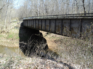
The next bridge is an old I-Beam rail road bridge.

View from the other side


One of the many rock cuts along this portion of the path, in most sections there is a running creek along side the path about 100 feet down.


Here we are coming back to the namesake tunnel.